

Digital Transformation / Geographic Information Systems (GIS)
GIS connects data to maps and integrates locations with descriptions and other information. GIS creates, maps, analyzes, and manages a variety of data.
These systems assist businesses in nearly every field to solve complex problems and create maps that share information to help users understand patterns, relationships, and geographic context. GIS can improve communication and enhance management decisions, changing how our world works.
Emerging technologies, new Esri offerings, and enterprise integration
Current state, future state infrastructure, software, architecture, data, workflow, and governance
Install, configure, migrate, upgrade, optimize, and implement your GIS project
Asset lifecycle management, decline curve and map integration, scenario management, and widgets
FME – ETL, platform consolidation, data warehouse architecture and implementation, dashboards, and KPIs
Support and maintenance, knowledge transfer, and training for your systems
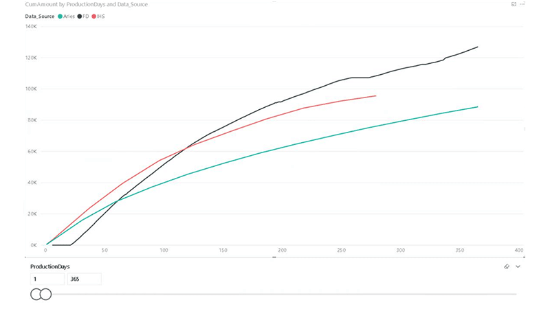
Revamp of the way the company visualized and analyzed its well production data
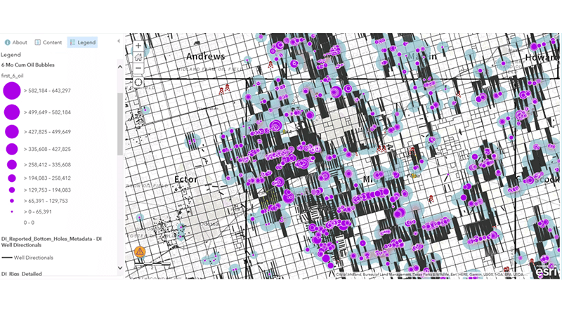
Global Upstream Geospatial Data Management analysis and roadmap
Fit for Purpose or “Off-the-Shelf”
| Cookie | Duration | Description |
|---|---|---|
| cookielawinfo-checkbox-analytics | 11 months | This cookie is set by GDPR Cookie Consent plugin. The cookie is used to store the user consent for the cookies in the category "Analytics". |
| cookielawinfo-checkbox-functional | 11 months | The cookie is set by GDPR cookie consent to record the user consent for the cookies in the category "Functional". |
| cookielawinfo-checkbox-necessary | 11 months | This cookie is set by GDPR Cookie Consent plugin. The cookies is used to store the user consent for the cookies in the category "Necessary". |
| cookielawinfo-checkbox-others | 11 months | This cookie is set by GDPR Cookie Consent plugin. The cookie is used to store the user consent for the cookies in the category "Other. |
| cookielawinfo-checkbox-performance | 11 months | This cookie is set by GDPR Cookie Consent plugin. The cookie is used to store the user consent for the cookies in the category "Performance". |
| viewed_cookie_policy | 11 months | The cookie is set by the GDPR Cookie Consent plugin and is used to store whether or not user has consented to the use of cookies. It does not store any personal data. |